In BOLD Bin: BOLD:AAF3284.Adult:
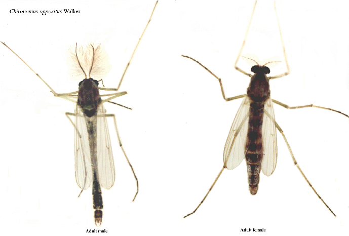
Adult male (left) and adult female (right) of C. oppositus. 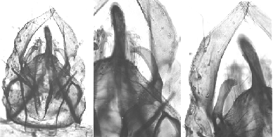
Male terminalia (left) and superior volsella (centre) and other superior volsella and gonostylus (right) of C. oppositus type specimen.
Superior volsella of this specimen of D-type, between d and e of Strenzke (1959).Details of the type specimen are given here.
Four forms were recognized by (Martin & Lee 1984), mainly on the basis of larval polytene chromosome banding patterns. A fifth form, noted by D.H.D. Edward (unpubl.), occurs in Western Australia
No means of reliably distinguishing the adults is known. However, the type specimen is a large adult and similar large adults were collected near the large central lakes of Tasmania, and these were associated with a single larval type, therefore called form oppositus (o).
The other forms are:
form connori (c)
form tyleri (t) - see C. 'tyleri'.
form whitei (w) - results for this form suggest that it may be a composite of several other more or less differentiated forms - see C. oppositus MD variants.
The forms can be reasonably separated on the basis of allozyme and inversion frequencies.
form 'edwardi' (e) - this should also be recognized as a distinct species.
All these forms are essentially similar in coloration and morphology of hypopygium. Further study is required to see if characters exist to separate the forms.
There is also a further related species, C. 'tasmaniensis' with only three polytene chromosomes, known from a single larvae
Molecular Data:mtCOI - GenBank (AF110155 - f. connori, KJ946667-KJ946677) and BOLD. These sequences are shared between the forms of C. oppositus and with C. 'tyleri', presumably due to ongoing hybridization.
mtCyt B - GenBank (AF109698 - f. connori) also KJ946795 & KJ946796
gb2B - Genbank (AJ003799)
CAD1 - GenBank (KJ946479 - KJ946493)
and other genes.
The basic evidence for the recognition of the forms was given in Martin (2011a).
Found: Australian Capital Territory - Acton (-35.30°°S, 149.12°E)(w); 5 Km O’Connor (w), Uriarra (-35.33°S, 148.85°E) (w).
New South Wales - Barmah Ferry (w); Boggy Swamp Creek, n & e. Putty (w); 13 Km s. Bombala (w); Camden
Sewage Ponds (-34.05°S, 150.68°E) (c, o, w); Colo (-33.42°S, 150.80°E) (o, w); Station Creek,
Delegate (-37.05°S, 151.93°E) (w); 30 Km n. Holbrook (abt.-36.0°S, abt 147.08°E) (w); Jeir Creek (-37.08°S, 149.07°E) (w);
Kiandra (-33.88°S, 150.00°E) (c, o, w); Macquarie Pass (-34.57°S, 150.66oE) (w); 3 Km s. Nowra (-34.90°S, 150.60°E) (w);
Tarago Swamp (-35.00°S, 149.50°E) (o, w); 13 Km n. Tooma Dam (-37.55°S, 145.87°E) (w or c).
South Australia - Barmera (-34.25°S, 140.47°E) (o); Lake Leake (37.617°S, 140.583°E) (o) and Lake Edward (37.633°S,
140.600°E) (o) via Kalangadoo; Mambray Ck, D.C. of Mt Remarkable -32.83°S, 137.98°E) (opp.gp.); Warren Gorge (-32.11°S,
138.00°E), n. Quorn (w); Wilpens Pound, Flinders Ranges (-31.88°S, 138.42°E) (w). Kangaroo Island: Kingscote (w).
Tasmania (type locality)(o): - Arthur River (c); Bakers Beach (w); Bellerive (c, o); Bicheno (c); Butler Island, Gordon River (o);
Cambridge (o); Campbelltown (o); Coles Bay (o); Fossey River (c, w); George Town (c, o); Geeveston (-43.16°S, 146.90°E) (o);
Ida Bay (c, o, w); Lake Crescent (o); Little Swanport (o); Manning River, Sandy Bay (w); Maydena –(42.67°S, 146.62°E) (c);
Montana (-41.55°S, 146.58°E); 15 Km Queenstown (c, o); Smithon (-40.83°S, 145.08°E) (c,o,w); Swansea (-42.13°S; 148.09°E) .
(c, o); Wynyard (c) Flinders Island - Mt. Strezleckie (w): King Island - Porky Lagoon (o); Sea Elephant River (c):
Victoria - Airies Inlet -38.47°S, 144.10°E) (w); Albert Park (-37.85°S, 145.05°E) (w); Anglesea (-38.38°S, 144.18°E) (c, o, w);
Armadale (-37.855°S, 145.000°E) (w); Ballarat East (-37.55°S, 143.88°E) (o, w); Balwyn North (o); Beech Forest; Box Hill North
(-39.82°S, 145.12°E) (w); Bulleen (-37.77°S, 145.09°E) (w); Exhibition Gardens, Carlton (37.78°S, 144.95°E) (w); Cann River
(-37.57°S, 149.15°E) (o, w); Cumberland River (w); Longlea (w); Eildon (-37.14°S, 145.54°E) (w); Elphinstone (-37.12°S,
144.33°E) (c, w); Emerald (-37.93°S, 145.43°E) (w); e. Forrest (-38.52°S, 143.73°E); Frankston (-38.08°S, 148.08°E) (w);
Harcourt (-37.02°S, 144.25°E); nr. Hepburn Springs (-37.26°S, 144.11°E) (c, w); Horden Vale (w); Kew North (-37.786oS,
145.043oE); between Linto & Skipton (-37.68oS, 143.46oE) (w); Little River (-37.93°S, 144.50°E); Lodge Rd.,
Grampians (-37.12°S, 142.30°E) (o, w); Longlea (-36.75°S, 144.33°E) (w); Davis Creek, Mallacoota (-37.57°S, 149.75°E) (o, w);
Manns Beach (o); Maryborough (w); Botanic Gardens, Melbourne (-37.83°S, 144.97°E) (w); Melbourne University (-37.796°S,
144.960°E) (w); Mitcham (-37.818°S, 145.197°E) (o); Moggs Creek, Angehook Forest Park, (-38.45°S, 144.05°E) (c, o, w);
Mount Macedon -37.42°S, 144.58°E) (c); Narbethong (-37.57°S, 145.65°E) (w); Orbost (-37.50°S, 148.33°E) (o);
w. Orbost (-37.50°S, 148.33°E) (o, w); Parker Road, Cape Horn (w); Panton Hills (-37.63°S, 145.23°E) (w); Preston West
(-37.74°S, 144.50°E) (w); Reedy Creek (c, o); nr. Sale (o); Sassafras (-38.58°S, 147.67°E) (w); Spout Creek, nr. Lorne (-38.461°S,
144.01°E) (w); Templestowe (-37.77°S, 145.11°E) (o, w); Upper Clear Spot; Vermont (-37.83°S, 145.20°E) (c w);
Wangaratta (-36.19°S 146.18°E); Warburton (-37.75°S, 145.70°E); Warrandyte (-37.77°S, 145.20°E) (c, o, w); West Preston (w);
Squeaky Beach & Tidal River, Wilson's Promontory (-39.02°S, 146,32°E) (w), Wilsons Promontory (-39.05°S; 146.32°E) (o, w);
Lake Elusive nr. Wingan Inlet (-37.73°S, 149.45°E); You Yangs reserve (-38.00°S, 144.46°E) (w).
Western Australia - Lake Gwellup (-31.867°S, 115.800°E) (e).
[ Return to Index| Go to C. oppositus immatures ]