C. 'februarius'Chironomus alternans a - Martin 1961, Lentzios & Stocker 1979; Lentzios et al. 1980; Martin & Lee 1984
Chironomus alternans Type II - Edward 1964
Chironomus februarius - Martin 1966 (manuscript name)
Chironomus februarius (Nomen nudum) - Martin 1967; 1969a; Cranston & Martin 1989; Bugledich et. al. 1999.In BOLD Bin: BOLD:AAG5440. Adult: Quite a variable species over the breadth of its distribution, being smaller in the north with some specimens half the size of those from further south.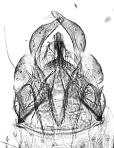
See description of C. februarius holotype male
Males:
Wings with anterior veins hardly darker than posterior; crossvein slightly darkened; wing length about 3.04 (2.5-4.6) mm. Antennal ratio (AR) about 3.19 (2.7-3.8); VR about 0.94-1.05.
Head, antennae and mouth parts varying from light to dark brown. Frontal tubercles present, mostly about 10-15 µm, but occasionally to 35 µm. Palpal proportions (µm) about 53 : 57 : 203 : 245 : 370. About 20 (15-28) clypeal setae.
Thorax has a greenish grey, greyish or brown background; stripes, postnotum and sternopleuron dark grey or brown; thorax pruinose.
Thoracic setae: acrostichal - 14 (9-22); dorsocentrals - 18 (8-25); prealars - 5.2 (4-7; supraalar 1; scutellum in approximately two rows - about 5.8 (2-9) in anterior row, and 12 (9-16) in posterior row (total 16.6: 10-25).
Legs yellowish brown or yellowish green without definite markings. LR about 1.56-1.89.
Male terminalia of C. 'februarius'. Leg lengths (microns) and proportions as follows:
| Fe
| Ti
| Ta1
| Ta2
| Ta3
| Ta4
| Ta5
| LR
| F/T
| BR
| PI
| 1366
| 1309
| 1607
| 1040
| 868
| 745
| 368
| 1.68 (1.56-1.89)
| 1.14 (1.08-1.32)
| 1.7 (0.7-2.6)
| PII
| 1392
| 1280
| 734
| 375
| 260
| 183
| 140
| 0.58 (0.54-0.60)
| 1.09 (1.04-1.18)
|
| PIII
| 1618
| 1631
| 1257
| 635
| 480
| 300
| 172
| 0.77 (0.70-0.98)
| 1.02 (0.85-1.25)
|
| Male abdomen variable in coloration, may be like that of C. cloacalis, or may have a dark band across the centre of each segment. About 7.2 (5-11) setae in a single pale area at centre of TIX.
Superior volsella closest to D(h)-type of Strenzke (1959). Inferior volsella, with simple setae, reaching about 2/3 along the length of anal point which is narrowed at the base. Gonosytlus moderately swollen and narrowing over the posterior third to half.Females:
Wing length about 3.41 (2.4-4.6, 51) mm; wing width about 0.90 (0.85-1.02) mm; VR 0.91 (0.89-0.94); about 17.3 (17-30) setae in anal fringe; 2.8 (2-4) Scf on brachiolum.
Head: Frontal tubercles present mostly about 33 (25-48) µm long, 11 (9-13) µm wide. Antennal proportions (micron)(% neck in brackets): 163 (55) : 140 (48) : 129 (50) : 119 (47) : 184; necks of segments 1-4 about 55 : 50 : 53 : 48 % of segment lengths respectively; AR 0.33 (0.22-0.38), A5/A1 1.13 (1.04-1.22). Palpal proportions (micron) about 56 : 52 : 186 : 233 : 329; P5/P4 1.40 (1.03-1.58; P5/P3 1.71 (1.33-1.97). Clypeus about 1.2x diameter antennal pedicel, with about 19.2 (15-28) clypeal setae.
Thorax colour generally similar to males, although stripes can have a grey or purplish tinge.14.3 (11-17) acrostichal setae; 17.3 (13-21) dorsocentrals; 5.4 (5-7) prealars; 1-2 supraalars, setae of scutellum in approximately two rows, about 6 (4-8) in anterior row, about 11 (10-13) in posterior row.
Legs generally yelowish, but with green or brown tinge. BR about 0.7-1.7.
Leg lengths (micron):
| Fe
| Ti
| Ta1
| Ta2
| Ta3
| Ta4
| Ta5
| LR
| F/T
| Ta4/Ti
| PI
| 1309
| 1052
| 2100
| 1005
| 900
| 874
| 392
| 1.61-1.86
| 1.00-1.38
| 0.67-0.81
| PII
| 1280
| 1229
| 760
| 364
| 259
| 188
| 142
| 0.52-0.61
| 1.02-1.14
|
| PIII
| 1581
| 1514
| 1215
| 585
| 340
| 290
| 180
| 0.68-0.77
| 0.96-1.03
|
| Abdomen similar to C. oppositus group, generally paler than C. cloacalis or with dark band on the proximal half of the segments II-V, then covering most of tergite.
Distinguished from C. cloacalis by the simple setae on the Inferior volsella, in contrast to the forked setae of C. cloacalis.
Cercus and segment X (at left) of C. februarius.Proposed Type series:
Holotype male: Echuca, Victoria (36.133°S, 144.750°E), 24.x.1962, J. Martin, (♂ 10)
Allotype female: Data as for holotype , 6.xii.1961 (♀ 9).
Paratypes: 9♂, 13♀, data as for holotype but various dates from February 1960 to October 1962.
Type material currently in collection of Jon Martin, but will eventually be distributed to the ANIC and other institutions. Molecular datamtCOI: numerous sequences are available in GenBank. Also in the BOLD database (see above). Found: New South Wales - Barmah Ferry (-36.02°S, 144.97°E); Cooranbong (-33.08°S, 151.45°E); Corowa (-36.008°S, 146.3835°E);
8 km Culcairn; Deniliquin (-35.53°S, 144.97°E); Griffith (-34.27°S, 146.03°E); Hexham Swamp, Hexham (-32.08°S, 151.70°E);
28 km n. Holbrook (-35.68°S, 147.33°E); Tenterfield (-29.10°S, 152.07°E); Thredbo Village (-38.50°S, 148.30°E);
Wheeny Creek(-33.45°S, 150.67°E), near Upper Colo; Willbriggie (-34.47°S, 146.03°E); West Wyalong (-33.917°S, 147.217°E).
Queensland - Atkinsons Dam(-27.42°S, 152.44°E); Toomba Lake (-20.00°S, 145.59°E), 100 km nw Charters Towers; Dawson River
(abt. -25.00°S, 150.05°E)(second crossing), Fernvale (-27.46°S, 152.67°E); 60 Km n. of Injune; Kilcoy (-26.94°S, 152.56°E);
Lotus Creek (-22.50°S, 149.16°E);Mackay (-21.14°S, 149.20°E); Noosaville; St. Lucia; Sarina (-21.42°S, 149.20°E);
Somerset Dam (-27.115°S, 152.555°E); Tarampa (-27.48°S, 152.55°E); Toowoomba (abt -27.60°S, 152.37°E); Common, Townesville;
Townesville South; Woodridge (-27.63°S, 153.10°E); Yeerongpilly.
South Australia - Waste water plant, Bolivar (Carew et al. 2013); Dawesley Hill, 1.6 Km e. Dawesley; Hawker; Lake Edward
(-37.633°S, 140.600°E); w. Kalangadoo; Brown Lake, Mt. Gambier; Oratunga Creek; Wilpena Creek (-31.88°S, 138.42°E),
Wilpena Pound, Flinders Ranges.
Victoria - Albert Park (-37.85°S, 145.05°E); Moggs Creek, vicinity Angehook Forest Park (-38.45°S, 144.05°E); Bairnsdale
(-37.42°S, 147.56°E); Ballarat (-37.56°S, 143.88°E); Balwyn North (-37.788°S, 145.075°E); Bendigo (-35.85°S, 144.70°E);
Bridgewater (-36.60°S, 143.95°E); Upper Clear Spot, Bright (-36.20°S, 145.05°E); Station Water, Cairnlea (Carew et al. 2013);
Cairnlea (Carew et al. 2013);Exhibition Gardens, Carlton; Casterton (-37.58°S, 143.25°E); Charlton (-36.27°S, 143.35°E);
Chiltern(-36.15°S, 146.60°E); Cohuna ((-35.80°S, 144.20°E); Corryong (-36.18°S, 147.88°E); Yarrunga Reserve, Croydon Hills
(Carew et al. 2013); Lake Cullulerane, Cullulerane (-34.277°S, 141.605°E); Echuca (-36.133°S, 144.750°E) (type locality);
Eildon (-37.14°S, 145.54°E); Elphinstone (-37.12°S, 144.33°E); Footscray Park (-37.79°S, 144.90°E); Gardners Creek, Melbourne
(Parsons unpubl); Stoney Creek Grampians (-34.17oS, 140.44oE); Granya Junction ()-36.10°S, 147.50°E);
7 Km n. Hepburn Springs;(-37.26°S, 144.01°E); Apex Park, Kerang (-37.62°S, 140.58°E); Kew Billabong, Kew (Carew et al. 2013);
You Yangs Park, Lara (-37.87°S, 144.33°E), LaTrobe University (Parsons, unpubl.); Royal Botanical Gardens (-37.50°S, 144.97°E)
and Zoological Gardens (-37.785°S, 144.952°E), Melbourne; Merbein (-37.78°S, 145.10°E); Nyah (-35.18°S, 143.33°E); 5 Km Orbost
(-37.70°S, 148.33°E); Paradise (-36.78°S, 143.08°E); Perrys Bridge (-38.00°S, 147.26°E); Edwardes Lake, Reservoir
(-37.71°S, 144.99°E); Sale (-38.10°S, 147.07°E); Shanklin upper wetland, Roxborough Park (Carew et al. 2013);
Settlers Orchard (Parsons, unpubl.); Stawell (-37.05°S, 142.77°E); Strathfieldsaye, Perrys Bridge (-38.00°S, 147.26°E); Emu Bottom,
Sunbury (-37.55°S, 144.74°E); Wallington (-38.20°S, 144.48°E); Apex Park, Wandella Creek (s. of Kerang) (abt -35.62°S, 140.62°E);
Wangaratta (-36.19°S, 146.18°E); Warrandyte South (-37.77°S, 145.20°E); Yarriambiak Creek, Warracknabeal
(-36.23°S, 146.43°E); Melbourne Water Metropolitan Farm, Werribee (-37.92°S, 144.67°E); ; Wycheproof (-36.08°S, 143.22°E).
Western Australia - Armadale (32.253°S, 116.015°E); Barker Swamp (-33.00°S, 115.30°E); Cape Vlaming (-32.01°S, 115.60°E),
and Serpentine Lake (-32.01°S, 115.43°E), Rottnest Is. (Wadjemup); Bell Swamp (-31.77°S, 116.03°E), Upper Swan;
Bibra Lake (-32.01°S, 115.82°E); Lake Goollelal (31.81°S, 115.80°E), Lake Gwellup; Lake Monger; Kingsley (Carew et al. 2013);
Murdoch Swamp (abt 32.1°S, 115.8°E); 1.5 Km s. Yarloop (32.97° 115.90°E).
Possibly also found on Norfolk Island - Bridle Trail, but may be a related species Although classed as a nomen nudum, this species was described and types designated in Martin (Ph.D. Thesis 1966). A multiple discriminant function analysis in this thesis indicated some morphological differences from the C. oppositus group, but none from C. cloacalis. However the males of the two species differ in the recurved setae of the Inferior Volsella, which are branched in C. cloacalis.
The females may differ from C. cloacalis in the means of a number of characters but there is overlap of the ranges (e.g. mean wing length 3.41 c.f. 4.15, but ranges overlap from 2.76-4.6) [ Return to Index| Go to C. 'februarius' immatures ] |