C. tepperi Skuse, 1889.In BOLD Bin: BOLD:AAW0677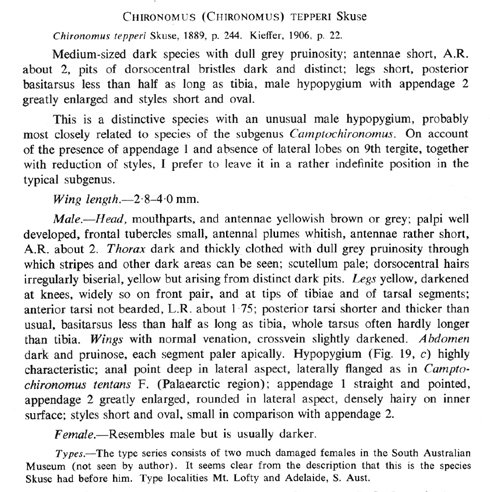
Redescription of the adults of C. tepperi
from Freeman (1961).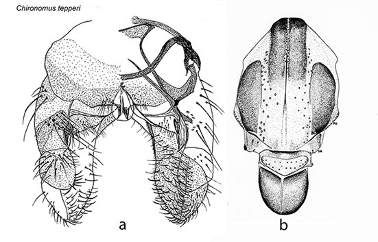
a. Male hypopygium of C. tepperi (Martin, unpubl.); b. thorax showing setae (Porter 1974)Male (additional data):
Wing length up to 5.0 mm, width abt 1.14 mm., VR abt 1.13, abt 15-20 setae in squamal fringe.Head: Frontal tubercles about 11 µm long and 11 µm across at base. Palp segments (micron): 65 : 80 : 233 : 256 : 290. Clypeal setae very variable – 18-42.
Thoracic setae also very variable: Acrostichal - abt 11-12; Dorsolateral - abt 28-31; Prealar - 9-17; Supra-alar abt 2; Scutellar 10-28.
Legs, quite short, relative proportions (micron):
| Fe
| Ti
| Ta1
| Ta2
| Ta3
| Ta4
| Ta5
| LR
| F/T
| BR
| PI
| 1920
| 1480
| 2320
| 1160
| 1000
| 880
| 390
| 1.57-1.75
| 1.30
| 1.5
| PII
| 1680
| 1760
| 760
| 440
| 360
| 190
| 138
| 0.43
| 0.95
|
| PIII
| 2140
| 2100
| 930
| 600
| 445
| 273
| 173
| 0.44
| 1.02
|
| 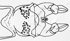
Patches of setae on tergite VIII
(From D.L. Porter, Ph.D. Thesis 1974) Abdomen: Two large patches of setae on tergite VIII, but none on tergite IX. Superior volsella of the D(f)-type of Strenzke (1959). Inferior volsella long and swollen with simple setae and extending beyond the gonostylus which is almost oval in shape.Female:
Wing length 4.16 mm, width 1.37 mm; VR 1.06; 5-6 Scf on brachiolum, at least 21 setae on squamal fringe.Head: Frontal tubercles tending to conical, 30 x 18 µm. Antennal proportions (micron with percentage of neck in brackets): 164 (27) : 94 (40) : 104 (40) : 108 (42) : 214. AR 0.45; A5/A1 about 1.3. Palp segments (micron) 85 : 70 : 233 : 248 : 421; P5/P4 abt.1.7; P5/P3 abt 1.81. Clypeal width about 1.8-1.9 times the diameter of the antennal pedicel; setae very variable – abt. 33 (10-51).
Thoracic setae also very variable: Acrostichal at least 18; Humeral – abt 6-9, essentially linear; Prealar - 7-9; Supra-alar - 1; Scutellar with posterior row of abt 26 (15-36) setae and 14 (9-21) in two or three anterior rows.
Legs, quite short, length (micron) and relative proportions:
| Fe
| Ti
| Ta1
| Ta2
| Ta3
| Ta4
| Ta5
| LR
| F/T
| Ta4/Ti
| PI
| 1520
| 1175
| 1760
| 810
| 720
| 660
| 330
| 1.48
| 1.26
| 0.55
| PII
| 1415
| 1455
| 645
| 440
| 360
| 290
| 225
| 0.44
| 0.97
|
| PIII
| 1670
| 1745
| 910
| 530
| 485
| 310
| 230
| 0.52
| 0.96
|
| BR 1.25; Fe1/Fe2 – 1.07

Terminal segments of adult female showing cercus and segment X.
Abdominal tergites dark and pruinose; segment X relatively wider than in other species with about 20 setae, margin of cercus generally rounded, sometimes with slight ventral bulge.This species has been gazetted for use in experimental assessment of environmental pollutants. Molecular Data:
Complete mitochondrial genome - GenBank JN861749.1
mtCOI - GenBank AF192211
mtCytB - GenBank AF192180
S-adenosylhomocysteine-β-hydrolase - KF740474
cystathionine-β-synthase - KF740475
cystathionine-γ-lyase - KF740476
γ-glutamylcysteine synthase - KF740473
Some genetic loci have been mapped to the polytene chromosomes using in situ-hybridization Found: South Australia - Mt Lofty (-34.97°S, 138.70°E) & Adelaide (-34.56°S, 138.30°E) (Type localities).
Australian Capitol Territory - Black Mountain, Canberra (both Freeman, 1961); Lake Burley Griffen.
New South Wales - Belaringa, Griffith, Hornsby, Lake Illawarra, Nyngan, Sydney, Trangie, Yass (all Freeman, 1961); Arrawarra
(30.06°S, 153.19°E); Corowa (36.08°S; 146.39°E); Forbes (33.38°S, 148.01°E); Marom Creek (28.88°S, 153.37°E);
Boggy Swamp Creek, abt 20 Km n. Putty (abt -32.42°S, 150.17°E); nr Rutheford Creek, about 35 Km n.e. White Cliffs; 7 Km e.
Wyalong; West Wyalong (-33.917°S, 147.217°E); Yanco (-34.60°S, 146.42°E).
Northern Territory - Nourlangie Rock Road, Kakadu N.P.; Ross River, East Macdonell Ranges (-23.70°S, 135.60°E).
Queensland - Burpengary, Eidsvold, Innisfail (-21.13°S, 149.18°E), Townsville, Watten (all Freeman, 1961);
Somerset Dam (-27.115°S, 152.555°E); Woodridge (-27.63°S, 153.10°E).
South Australia - Didicoolum; Mt. Eyre (both Freeman, 1961); 3 Km se. Emu Bay; Kangaroo Island; Cook (-30.64°S, 130.44°E);
Lock (-33.57°S, 135.76°E); Paringa (-34.16°S, 140.78°E); Renmark (-34.17°S, 140.73°E); Victor Harbour (-38.35°S, 138.37°E).
Tasmania - Bellerive (-42.83°S, 147.33°E).
Victoria - Chiltern, Melbourne, Pianglo, Sandringham, Sealake (Freeman, 1961); Albert Park; Bendigo (-36.60°S, 144.30°E);
Box Hill North (-39.82°S, 145.12°E); Carrum; 1.6 Km e, Cavendish (-37.52°S, 142.08°E); 15 Km Cherrypool (-37.11°S,
142.18°E); Chiltern (-36.15°S, 146.60°E); Clunes (-37.30°S, 143.78°E); 1.6 Km s. Dunach; Echuca (-36.15°S, 144.75°E);
Eildon (-37.14°S, 145.54°E); Elphinstone(-37.07°S, 144.20°E); Alistair Knox Park, Eltham (Carew et al. 2013);
Woodland Park, Essendon (Carew et al. 2013); 8 Km s. Euroa (-36.76°S, 145.57°E);
13 Km w. Harrow; Jamieson (-37.32°S, 148.17°E); 1.6 Km w. Laverton (-37.858°S, 144.772°E);
Explosives Rd., Laverton (-37.858°S, 144.773°E); Linton (-37.68°S, 143.57°E); Lynbrook (Carew et al. 2013);
Mapley Farm (Carew et al. 2013); Merbein (-37.78°S, 145.09°E); Mildura; Miners Rest; Moggs Creek (-38.27°S, 144.03°E);
Mt. Waverley; Albert Park Lake, South Melbourne(-37.85°S, 145.06°E); 10 Km w. Natiuk; 9.5 Km w. Natimuk;
Nyah (-35.18°S, 143.33°E); Parkville(-37.47°S, 144.57°E); 5.5 Km e. Smythesdale (-37.65°S, 143.68°E); ; 5 Km n.e. Stawell;
5km w. Streatham; St. Arnaud (-36.62°S, 143.25°E); Taylors Lakes (Carew et al. 2013); Tungamah (-36.15°S, 145.87°E); ;
Vermont (-37.50°S, 1465.12°E); Wallington -38.20°S, 144.48°E); 7 Km s. Wangaratta (-36.21°S, 146.18°E)
& Wangaratta (-36.19°S, 146.18°E); Melbourne Water Metropolitan Farm, Werribee (-37.92°S, 144.67°E); Wickliffe;
16 Km w. Winchelsea(-38.23°S, 143.98°E); Woohlpooer (-37.21°S, 142.10°E); Swimming pool, Yallourn(-38.18°S, 146.33°E);
You Yangs Reserve (-38.00°S, 144.45°E).
Western Australia - Esperance (-33.85°S, 121.87°E); Lake Grace, Leederville, Millstream Station, and Perth (all Freeman, 1961);
13 Km n. Hopetoun; 11th Road Pond, Armadale; Leederville; Swan River foreshore, Nedlands (all Edward 1964);
Kalgoorlie (-31.75°S, 127.45°E). [ Return to Index| Go to C. tepperi immatures ] |